Gazing Into the Abyss: Harnessing Hydrographic Tech to Map the World’s Ocean
By Laurel Gallaudet
A bathymetric map of the Mariana Trench and surrounding seafloor showing variation in depth with color. Detailed maps like this are what we aim to capture for the entire ocean.
Image courtesy NOAA NCEIMapping the ocean is no longer an endeavor merely undergone for the fascination of scientific and explorative intrigue. The need for higher-resolution and more extensive imagery and mapping of our oceans has become a matter of national and international interest central to a range of different sectors. Whether marine transportation, fisheries management, mining for critical minerals, offshore energy, or defense, an understanding of the nature of the seabed is increasingly essential for economic, national, and natural security. The ocean on Earth cover 95% of our planet: and yet, only 25% of it has been mapped to a level acceptable to modern day standards. We have even mapped the surfaces of Mars and the Moon to a higher resolution than that of the oceans on our own planet. How are we as a society and as a nation attempting to rectify this deficiency and improve our oceanographic knowledge of our ocean landscape?
The U.S. recently recognized this need to map our when the National Oceanic and Atmospheric Administration (NOAA) developed the National Ocean Mapping, Exploration, and Characterization (NOMEC) strategy and plan. The Nippon Foundation and GEBCO initiated the Seabed 2030 project with similar goals. Together, both initiatives rely on various forms of hydrographic technology.
Ship-mounted multibeam sonar technology transmits directed acoustic pulses at the ocean floor to detect changes in depth in order to form a three-dimensional understanding of the seafloor landscape. This technology has been used for decades to collect bathymetric data for nautical charts, conduct offshore energy siting assessments, and perform benthic studies for science.
Satellite-derived bathymetry (SDB) is a technology that uses optical image data from satellites or aircraft to estimate the seafloor depth. A lower cost technique, it employs algorithms which simulate multispectral signal attenuation, which is only effective in areas with relatively shallow and clear water.
Airborne bathymetric LiDAR is a more recently developed technology which uses green lasers that transmit optical signals to determine depth. The benefit of this method is that it does not require surveying from ocean going vessels, making it safer and more efficient for collecting data. Its effectiveness, however, is limited to relatively shallow and clear areas of water.
The most recent development in ocean mapping technology is the increasing use of all domain survey vehicles in the form of AUVs, UUVs, UAVs, USVs, and even hybrid AUV/USVs. These vehicles can be equipped with a range of sensors including the ones mentioned above, expanding their reach to deeper and more remote areas of the ocean and decreasing the need for putting vessels, aircraft, and crew into dangerous areas or on long expeditions.
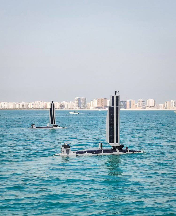
Fueled by the ongoing revolution in artificial intelligence, autonomous systems are experiencing some of the greatest growth in the field of hydrographic tech, and a few of the most recent developments are a sign of what is yet to come. For USVs, Exail’s DriX O-16 is the most capable transoceanic platform to date, featuring multibeam sonar and a sub bottom profiler. The Saildrone Voyager is another bathymetric USV designed for nearshore bathymetric survey as well as maritime security missions. Powered primarily by renewable energy with solar panels and a sail, these vessels can maximize time at sea without needing to be checked or recharged by a crew.
Numerous AUVs and UUVs with proficiencies for varying depths up to 6000 meters have been on the market for over two decades, expanding our reach into the far depths of the ocean landscape beyond shipboard systems. Prominent platform classes with multibeam or sidescan imaging sonar include Kongsberg’s Hugin and Huntington Ingalls REMUS AUVs, as well as Klein, Iver, and Bluefin UUVs. New to the scene is Bedrock Ocean Exploration’s 100% green AUV which provides bathymetric data as a service (DaaS).
LiDAR scanners can be installed on various AUVs and bathymetric UAVs as well, enabling higher maneuverability and shipboard deployment. AUVs and UAVs offer the ability to collect data with different instruments in various resolutions at the same time. Though LiDAR is traditionally deployed on airborne craft, the offshore oil and gas industry have used these sensors on AUVs for high resolution inspection and survey, demonstrating their suitability for fine scale hydrography.
A brand-new vessel being developed by Ocean Aero would offer expanded capabilities to a single data collection vehicle in the form of a hybrid USV/AUV they call an AUSV (Autonomous Underwater and Surface Vehicle). The TRITON can sail above and submerge using adaptations such as its collapsable payload wing. With these developments, the TRITON can handle missions across a range of industries and can be used in applications in defense, research, and off-shore energy sectors.
In medieval times, nautical charts were rife with uncertainty and an absence of certified sounding data. Unexplored areas were often marked with mythical beasts, dragons and sea creatures representing a fear of the unknown. Even today, our understanding of the seafloor is sorely lacking. Yet, the more we progress in autonomous seafloor mapping and imaging technology, it is safe to say that these dragon’s days are numbered.
About the Author
Laurel Gallaudet, B.A., is a second-year Master's student in the Composition, Rhetoric, and Digital Media program at Nova Southeastern University's (NSU), where she obtained her bachelor of arts in Strategic Communication and Marine Biology. She is the Chief Marketing Officer of Ocean STL Consulting, LLC and has worked on several science communication projects with NSU’s marine sciences departments.
