USM and NOAA Utilize SeaTrac USV for Offshore Data Collection

The demand for innovative solutions to explore and protect the world’s oceans is surging. Uncrewed Surface Vehicles (USVs) are at the forefront of this revolution, rapidly transforming how we study, monitor and utilize marine environments. Driven by the need for efficient data collection, advanced surveillance, and autonomous operations, the USV market is experiencing unprecedented growth. With applications spanning oceanography, hydrography, and environmental monitoring, these versatile platforms are redefining industry standards.
SeaTrac, a pioneer in USV technology, is at the forefront of this revolution. The advanced SP-48 platform is engineered to excel in both inshore and open-ocean environments, delivering critical, reliable data. A recent operation in turbulent open-ocean waters put the platform to the test.
A Mission to Map
In December 2023, SeaTrac embarked on a 14-day mission to map potential hypoxic zones in the U.S. Gulf of Mexico (GMO). Partnering with the University of Southern Mississippi (USM) and NOAA's Office of Marine and Aviation Operations (OMAO), the goal was to demonstrate the effectiveness of an uncrewed system in gathering and transmitting real-time data while reducing the manpower and resources traditionally required.
Operating remotely from SeaTrac’s Marblehead, Mass., headquarters, scientists piloted the SeaTrac SP-48 USV, equipped with a suite of advanced sensors including a winch-deployed AML-3 sonde for profiling and hypoxia mapping. The USV transmitted data in real-time to USM for quality control, while a crewed vessel collected comparative data for validation.
Overcoming Challenges
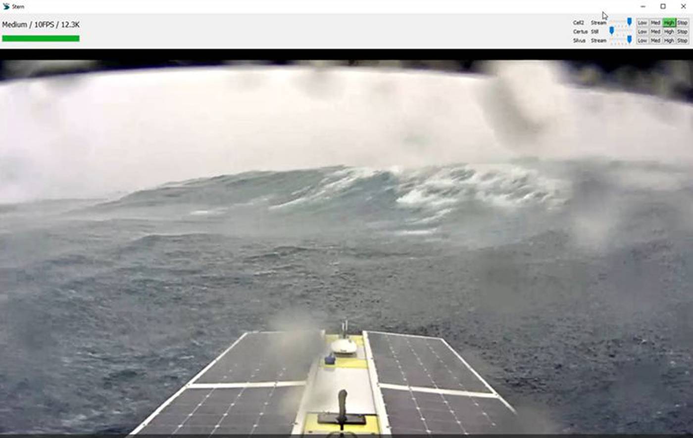
Operating in the harsh conditions of the GOM in December presented significant challenges. High winds, rough seas and limited sunlight for battery charging tested the limits of the USV. However, SeaTrac proactively managed the power budget by running at efficient speeds (<2.5 kts) and by duty-cycling payloads and/or station-keeping.
Ensuring accurate hypoxia mapping required precise depth control – within one meter of the seafloor – and was achieved by developing a bottom-detection capability for the winch. Additionally, operators implemented wireless charging for the AML-3 sonde to enable extended sampling durations. Robust communication protocols guaranteed reliable data transfer, even in remote areas.
Unprecedented Results
Despite challenging conditions, the SeaTrac SP-48 successfully collected high-quality data at 31 stations over 220 nautical miles, demonstrating its reliability, endurance and capabilities for scientific missions. The USV operated continuously, holding position without manual intervention, and requiring minimal remote pilot monitoring.
“SeaTrac's SP-48 and transom winch were successful in significantly reducing the on-site personnel needed for coastal hypoxia mapping despite unfavorable sea states and congested coastal corridors. Even more impressive was the boat’s responsiveness: At no point was the vehicle unresponsive, and all data was received into our CUBEnet portal in a timely manner. We look forward to incorporating SeaTrac technology into future research." - Jason McKenna, PhD, PG; director of research, development, testing, evaluation & training (RDTE&T); USM
SeaTrac's successful mission in the Gulf of Mexico is ongoing, this time with multiple USVs. It is continuing this critical work as a partner to USM and NOAA to gather additional mapping data, which will be compared for quality against the data collected by the crewed vessel. Once complete, the project will mark yet another significant milestone in the development and application of USV technology.
“Our continuing work highlights SP-48’s ability to replace crewed vessels, avoiding the danger present in humans performing the work manually. This also presents as a cost-effective solution, while the real-time data uploads help to advance operational oceanography and enhance the missions of NOAA,” said SeaTrac Co-Founder Jigger Herman.
Download a Copy of the Case Study
To download a copy of the mission’s case study and better understand each challenge the SP-48 overcame, click here.
SeaTrac’s platform excels in a number of other applications for defense, energy and other environmental projects. Its broad array of compatible sensors and intuitive software controls provide access to a wide range of environments and marine data. Learn more at seatrac.com.
