Reality Capture for Safer Marine Terminal Inspections
Marine terminal inspections can be risky, with several factors derailing required and routine inspections, like accidental releases of toxic materials, cargo handling accidents, traffic-related incidents, and drowning. Automation and computerized monitoring are increasing the complexity of modern ships, making inspections even more time-consuming and sometimes requiring additional inspectors. To address all these issues, marine terminal inspectors are turning to reality capture technology.
By Julita Amarante Miszkowska, product engineer, Leica Geosystems
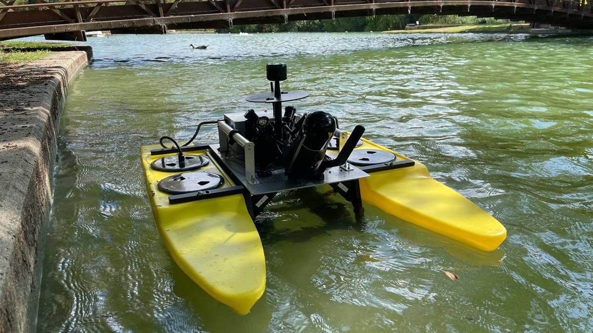
The Leica BLK ARC is secured onto a USV allowing a crew to remotely control the vessel and capture 3D data of the terminal for inspections.
What is reality capture technology?
Reality capture is a way to acquire data that can be used to re-create a space, such as a marine terminal, in a digital 2D or 3D format. The digital format allows you to establish the existing conditions of the terminal, so you have a record for closer examination and ready reference. The data can be acquired through various technologies such as 3D laser scanning (LiDAR) and photogrammetry.
Before reality capture, documenting and inspecting required a specialized crew and bulky equipment. Additionally, the area had to be closed off for hours. In marine terminals, inspectors and divers had to put their equipment and diving gear into boats. From there, they would make their way under the infrastructure to inspect the terminals and platforms. Many times, space between the water and the structure was tight — only a few feet, making accurate and quick inspections challenging.
This can lead to two likely scenarios. First, the space is not sufficiently documented, leaving a wider margin of safety error for passengers, ships and cargo. The second is a higher likelihood of inspections being delayed, waiting for the perfect conditions.
Then came advances in digital technology and reality capture. Over the past decade, the form factor has evolved with various options available based on the user’s needs. Today, inspectors can use mobile handheld reality capture products to scan an area by pressing a single button. Other products offer autonomous reality capture where the user can direct a UAV or a robot from land without extensive training. While the reality capture form factors may vary, the process always involves scanning the space.
Reality Capture in Action
To make terminal inspections safer and more efficient, Abyss Solutions, providing inspections across sectors including marine terminals, built a proprietary unmanned surface vessel (USV). The remotely operated floating vessel is customized with multiple propellers for fast, versatile, and accurate data capture. It also features lighting rigs and is painted bright yellow for high visibility and efficient navigation.
For more in-depth inspections of terminals, Abyss added an autonomous reality capture product to their platform. The Leica BLK ARC is lightweight, configurable, and enables mobile 3D LiDAR mapping in complex environments. By securing the BLK ARC onto a USV, a small crew can remotely control the vessel capturing up close 3D data of the terminal to expediently conduct an inspection.
The reality capture technology scans and captures data as the vessel moves along the water. It improves marine technology inspections using simultaneous localization and mapping (SLAM) technology. This enables autonomous navigation because the product understands its surroundings, knowing the areas it has previously scanned without relying on maps. For the crew on land, this capability provides instant review of what has been captured as it is happening to confirm its completeness and accuracy.
The data that is captured provides a comprehensive view of the marine terminal and is presented in a point cloud. This often allows an in-depth look at damage class denominations, cracking/sprawling on concrete, rust, corrosion, anomalies on pipes, and more.

Analyzing a marine terminal with a digital twin
From there, every component is labeled and tagged, allowing users to also view the metadata. This includes structural health, external corrosion, circuit names, pipe routes, and how different structures connect to the overall platform.
This informs the creation of 3D smart digital twins containing detailed images embedded with metadata. The metadata provides the necessary information to make informed decisions regarding maintenance and repairs.
Navigating the digital twins is as simple as using Google Maps. Users explore their assets by clicking on a specific area to see all related data for it. Since the images are panoramic, they provide a real-life perspective of the inspection site. With digital twins, an immersive 3D environment is created, allowing inspectors to fully assess the terminal digitally, including under-dock areas, splash zone piles, topsides, and subsea components.
Further, using artificial intelligence (AI) augments the data by pinpointing high-risk areas with precision. It offers additional insight into what needs to be replaced, examines if chipping has or might occur, assesses concrete piles and degradation, and measures detected defects.
Safer Inspections
Reality capture technology provides marine terminal operators with a way to reduce inspection time using fewer resources while enhancing the quality of the inspection process. Having better insights into the state of the terminal results in safer environments through proactive maintenance and operational efficiency.
A recent example from Abyss Solutions is the inspection of an older section of a marine terminal. The technology detected a loose piece of I-beam that fell onto the USV. If a human was conducting the inspection, they could have been hurt.
Delayed maintenance on marine terminals increases risk. Today’s technology makes it easier to identify damage and proactively get ahead of potential issues. It ensures the safe loading and unloading of cargo, simplifies proper documentation for compliance and safety record keeping, and strengthens ongoing maintenance programs.

About the Author
Julita Amarante Miszkowska is a product engineer at Leica Geosystems, part of Hexagon. She has a background in building surveying, QA on CAD drawings and BIM models, and producing 3D models using point clouds. Prior to joining Leica Geosystems, Julita was a surveyor at PCA Geo-Surveyors, Ltd.

